

Potential
Houston Levee Failures: Reports Indicate that Reservoirs are Being
Strained to the Breaking Point
Such unprecedented rainfall totals caused city officials to warn that: “This event has the potential to exceed a 1,000 year flood plain threshold.” It’s worth noting that the Levees in Fort Bend County were designed only to manage a 100 year flood event and that the expected 59 foot crest of the Brazos River represented an 800 year flood event.
28
August, 2017
DEVELOPING
STORY:
News
reports tonight from Houston
KTRK indicated
that water levels at Addicks and Barker Reservoirs were continuing to
rise sharply despite controlled releases starting at 1 AM on Monday.
According to these reports, the reservoirs had received upwards of 25
inches of rainfall. The National Weather Service indicated that
another 25 inches may be on the way in total. And despite the
controlled release, reservoir levels were continuing to rise at a
rate of 4 inches per hour.
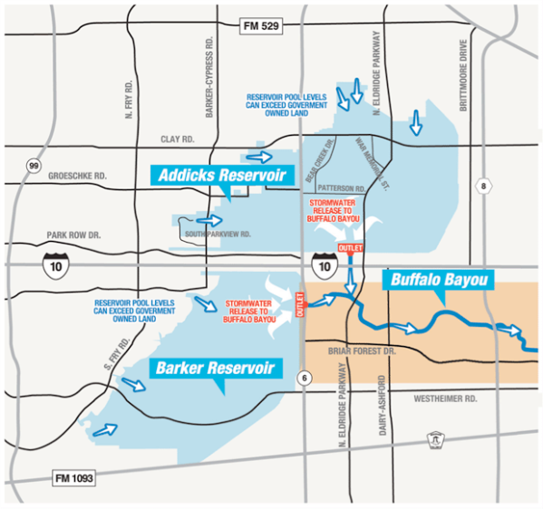
(Addicks and Barker Reservoirs spill into Buffalo Bayou, which then flows into downtown Houston. Earlier today controlled releases were begun in an attempt to slow water rise in the reservoirs. This release is failing to prevent rapid water rise within and around these reservoirs. Movement of flood waters into the reservoirs is pushing waters into subdivisions near the reservoirs even as risk of levee failure is rising. Image source: Harris County Flood Control District and Weather Underground.)
Such unprecedented rainfall totals caused city officials to warn that: “This event has the potential to exceed a 1,000 year flood plain threshold.” It’s worth noting that the Levees in Fort Bend County were designed only to manage a 100 year flood event and that the expected 59 foot crest of the Brazos River represented an 800 year flood event.
Levees in Fort Bend county designed for 100 year flood. The 59' crest forecast for the Brazos River at Richmond is a 800 year flood via EM
But
by evening, very heavy thunderstorms were running in to Houston
across Galveston Bay. These storms again pummeled the city with
extraordinary rainfall amounts — pushing flood thresholds still
higher.
As
a result, concern about the communities surrounding these reservoirs
is hitting a fever pitch. Flooding is now expected in all of the 41
city subdivisions surrounding Barker and also in all of the 52
subdivisions surrounding Addicks. In addition, three other
neighborhoods could see flooding if water flanks the Addicks
spillway.
In addition to these neighborhoods, officials have called for a mandatory evacuation of Inverness Forest on Cypress Creek and Northwood Pines on Spring Creek as a result of potential levee failures.
Throughout
the day, there have been numerous indications that these reservoirs
were under serious stress as more and more water rushed downstream.
As of late afternoon, water levels had risen to 105 feet in the
Barker reservoir. Observers of levees at the time had already noted
that water was near overtopping in some places. This tweet from Jeff
Linder shows water very close to the top of the Inverness Levee.


By
evening, Barker had topped 108 feet with the water still rapidly
rising. Meanwhile, a
dam upstream in Brazos County burst at 9 PM —
further adding to the torrent heading toward Houston. With imminent
danger of worse floods approaching, the National
Weather Service subsequently issued a very clear warning that
residents in the impacted neighborhoods should evacuate before 11 PM
(CDT) or risk being stranded.
Such a clear warning was an indication that disaster officials
expected a high risk that at least some of the impacted levees would
be breached or spill over.
(UPDATES
TO FOLLOW)
RELATED
REPORTS AND INFORMATION:

Northwood pines civil emergency alert evacuation order due to risk of levee breach. #Houston #TexasFlood #Harvey

The Brazos River is now at major flood stage. It's 4.8' from last years record & 9.0' from the forecasted crest.

Links:
Hat
tip to wili
Hat
tip to eleggua
Hat
tip to Andy in San Diego
No comments:
Post a Comment
Note: only a member of this blog may post a comment.